Where to Find the Best Waterfalls in NSW
Looking for the best waterfalls in NSW? We have just spent a couple of months driving around the state and have visited many beautiful falls along the way. The walks we did to find them were among our favourite parts of the trip. We shared our finds here so that you can enjoy them too.
These natural wonders seem to delight almost everyone, so adding a couple to your next itinerary is a no brainer.
We will continue to add more waterfalls as we visit, so bookmark this page for the next time you are planning a day out.
We have yet to master the art of waterfall photography, so our Samsung S20 and GoPro have captured the photos you see.
Note – Before you set off to explore any of these waterfalls, please check that access has not been affected by bushfire damage or weather incidents.
Chasing Waterfalls on a NSW Road Trip
We recently took a 5-week road trip around NSW, checking out the best beaches, national parks and waterfalls and putting together some great new itineraries. Who knew there were so many fantastic falls in our home state.
Since our third find, this song by TLC has been stuck in my head, and I find myself bursting into song on the approach of the next waterfall.
NSW Waterfall Map
We have listed the most impressive drops we have discovered on this and previous trips in alphabetical order because ranking them any other way is too contentious.
Finally, we have answered the most common questions in our FB community about waterfalls near Sydney at the bottom of the page.
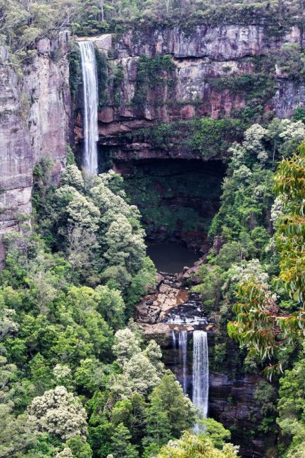
Apsley Falls – Oxley Wild Rivers National Park
Two drops make up Apsley Falls, a tiered waterfall in Central NSW. The first falls 65m off a deep gorge, and then just under a km away, the second fall of 58 drops to the bottom of Apsley Gorge.
The people of the Dunghutti Nation are the traditional owners of the land at Apsley Falls. The site is an important part of their Dreamtime stories that tell of the gorge being created by the Rainbow Serpent.
On our visit in late August 2020, there was a decent amount of water running over the falls after some heavy rain about ten days earlier. However, the gorge itself is quite a sight, so it’s worth stopping here even in times of drought.
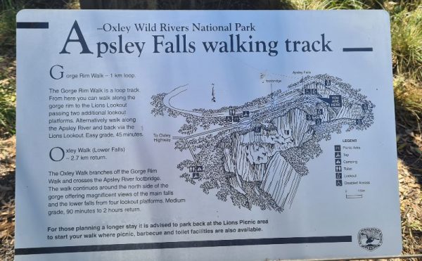
Walking Tracks At Apsley Falls
There are a couple of walking tracks to choose from. The first one, Macmillian Lookout, is where we took the shot above.
If you want to see the lower falls, you will need to take a short walk which brings you to three more viewing platforms. This walk takes about 90 minutes. These stairs, which allow you to get a better view, were closed for repairs on our visit, and they listed no date for when this work will be finished.
- Apsley Gorge Rim walking track is a short, easy 1.2km walk (Grade 2) between Macmillian and Lions Lookout. It includes two other platforms that overlook the gorge. One of these Landslide Lookout is wheelchair accessible from the main car park.
- The Oxley Walk is another track that runs along the ridge above the first lookout takes you further around the gorge for a more direct view to the face of the fall.
This is a great lunch stop with a good-sized picnic ground, plenty of tables and undercover BBQs.
Tip: Want to stay awhile? As you enter the park from the Oxley Highway, you will find a small campground – about ten sites set among white gums. You can walk from the campground to the falls along a track that includes Landslide Lookout.
Where: Oxley Wild Rivers National Park – the falls are 20km east of Walcha.
Difficulty Easy, both Apsley Falls’ main lookout and Landside Lookout are wheelchair accessible.
Road Access: Gravel road suitable for all vehicles and parking available for large motorhomes and caravans
Belmore Falls – Morton National Park
Belmore Falls in the northeast of Morton National Park is a great day trip from Sydney. This waterfall offers bang for your buck with both plunge and tiered drops on display. The water runs from Barrengarry Creek, and after heavy rains, this waterfall is spectacular and well worth the drive south from Sydney.
Belmore Falls was named after the then Governor of NSW Somerset Lowry-Corry, 4th Earl Belmore.
Walking tracks at Belmore Falls
The Belmore Falls walking track is a 1.8km trail that begins at the Hindmarsh Lookout parking area. It’s a relatively straightforward walk, but there are stairs and slight slopes.
Hindmarsh Lookout is 800m along the track; it does not offer views of the waterfall but provides a lovely outlook over Kangaroo Valley. Beyond this are two more viewpoints, Belmore Falls lookout, which we think gives the best view and then the imaginatively named second lookout. The walk to the base is closed because of fallen trees and unstable ground.
There is also a poorly marked lookout further along the road. From here, you can see the top of the falls. It’s worth hunting down – you can find the exact location on this Google map.
Where: 6.5km from Robertson in the Illawarra/Southern Highlands region
Road Access: a narrow winding dirt road – if using a rental vehicle, be sure they cover you for dirt roads – many campers and RVs are not.
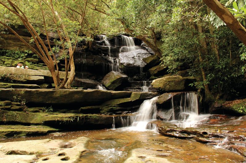
Carrington Falls – Budderoo National Park
The pick of the south coast waterfalls for many, Carrington Falls is classed as a plunge waterfall. There is a 50m drop in the multi-tiered falls to the valley floor below.
Walks at Carrington Falls
The Carrington Falls walking track is an easy 35-minute loop walk with just a short section of stairs. There are three lookouts, the first is Falls View Lookout, and anyone not able to walk far might be happy to stop here. The next lookout is at the base of a set of metal stairs and gives a magnificent view of the area. Finally, you head back up and reach Valley View Lookout.
It is possible to swim at Carrington Falls, although we have never done this.
*You can make your way to the bottom of Carrington Falls, but you need to be an experienced hiker with appropriate gear to attempt this. It is a very challenging track. Get more details from the Fitzroy Falls Visitors Centre.
Tip: Stay awhile; the National Parks runs Carrington Falls Campground and offers six tent sites. The cost is $12 for two adults.
Bonus tip: Stop at the nearby Robertson Pie Shop for a meat or fruit pie.
Where: Kangaroo Valley, 7km east of Robertson in the Illawarra/Southern Highlands region. View the location on Google maps here.
Difficulty: Easy – some stairs, but suitable for most. The first lookout is an easy walk.
Road Access: Easy, a sealed road leads to the parking area.
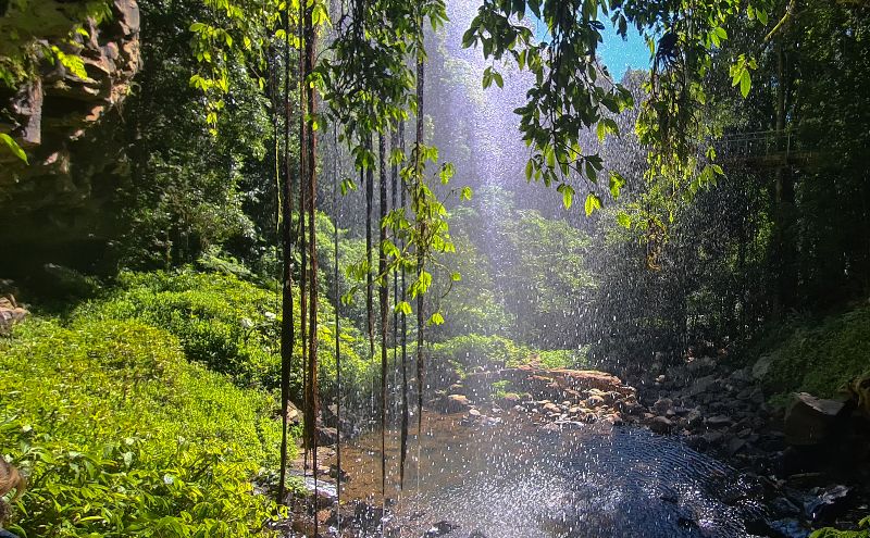
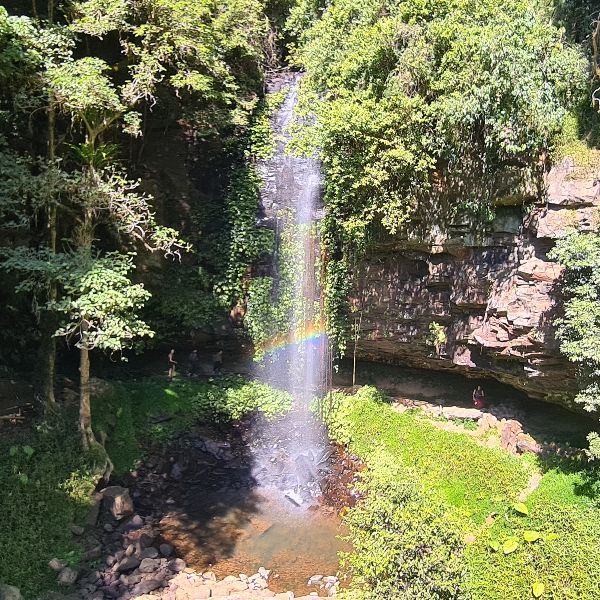
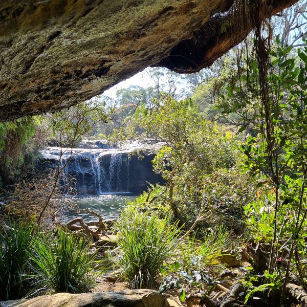
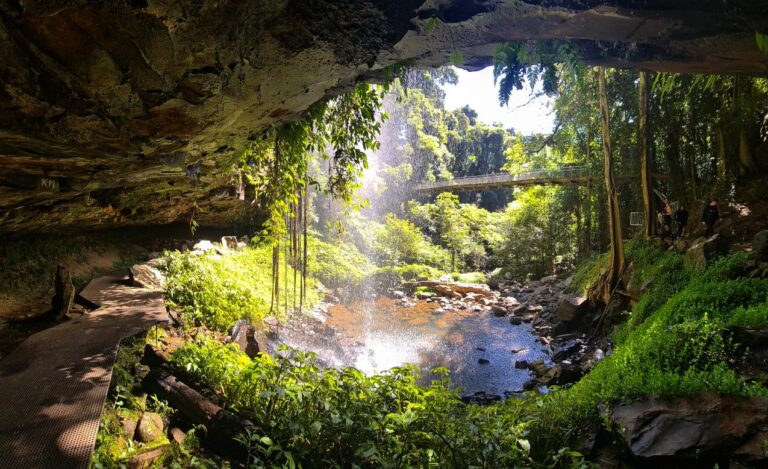
Crystal Shower Falls – Dorrigo National Park
Crystal Shower Falls in Dorrigo National park is one of the prettiest waterfalls we have visited in Australia and one of the very few waterfalls in the state you can easily walk behind.
It’s a photographer’s dream!
Dorrigo National Park is part of the UNESCO Gondwana Rainforest listing and should be a stop on any visit to this part of the state as either a day trip from Coffs Harbour or a stop off along the Waterfall Way.
We recommend you allow at least two hours for your visit to the park, so you have time for the entire 6.6km Wonga Walk that takes in both Crystal and nearby Tristania Falls and some of the most beautiful rainforests we have experienced in NSW.
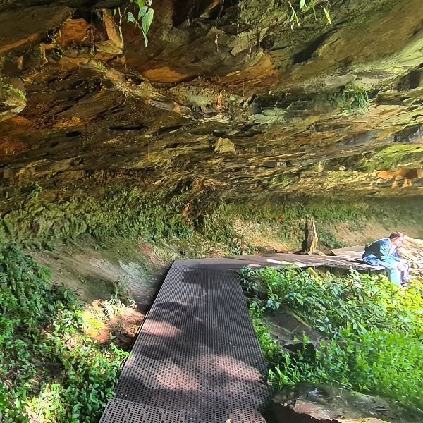
Tip: If you are short of time or don’t have the energy for the whole walk, you can reach Crystal Falls from the Glade picnic area car park – from here, it’s only 3.5km return walk.
If you arrive early in the day, you may find you have the place to yourself, as many people don’t realise you can enter the park before the Visitor Centre opens at 9am.
Where: Dorrigo National Park – the falls are reached from the Rainforest Visitors Centre
Difficulty: Neither of the waterfall walks is accessible to regular wheelchair users, although there is a trail rider available from the park.
Road access: Easy access, short turn off from highway along a sealed road – 2km from Dorrigo town centre.
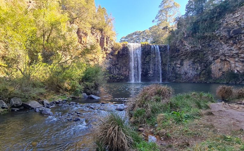
Dangar Falls – Dorrigo
Dangar Falls is a plunge waterfall with a great swimming area at the base. On the Bielsdown River, just one km from Dorrigo township, these falls are the easiest to access in the area.
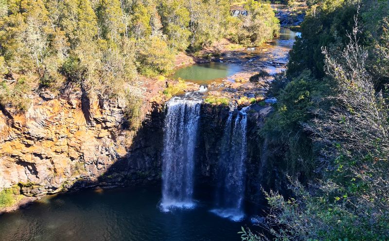
The viewing platform at the top is tiny, so you may need to wait your turn to get into the front and take your shot, especially if you visit on the weekend.
There is a picnic area, a playground and toilets next to the falls. There is often a small coffee cart set up – the coffee was great on our visit.
The walk to the base is suitable for most levels of fitness; if you have been spending a bit too much time on the couch, you may find the walk back to the top gets the heart started, but it’s not difficult at all, just take you time and agree to schedule more walks into your week when you get home 😉
The return walk, including lots of stops for photos, will take less than 30 minutes.
Tip: If you drive the Waterfall Way, you can camp here right by the walkway. There is a campground on private property, but no free camping is allowed nearby. It’s a good idea to book in advance. It was booked out when we went past last month, and they consider this low season.
Where: Dorrigo, just east of Dorrigo National Park
Difficulty: There are a few stairs and some uneven ground as you reach the base, but most of the walk is on a formed path.
Road access: Easy, sealed road and plenty of parking for large vehicles
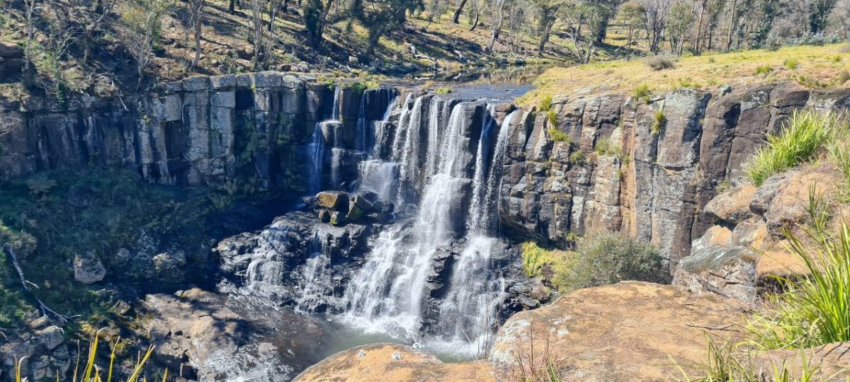
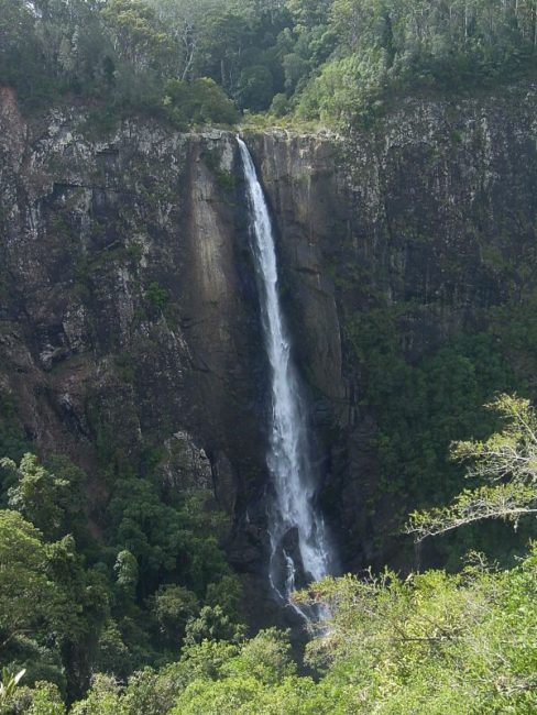
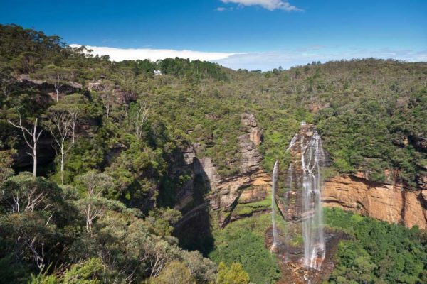
Ebor Falls – Guy Fawkes National Park
Ebor Falls is along the Waterfall Way in Guy Fawkes River National Park. This superb two-tiered drop is my favourite waterfall in NSW.
Water drops off the 115 metres (377 ft) drop year-round, so if you visit the area during drought, this is your best bet for an impressive view.
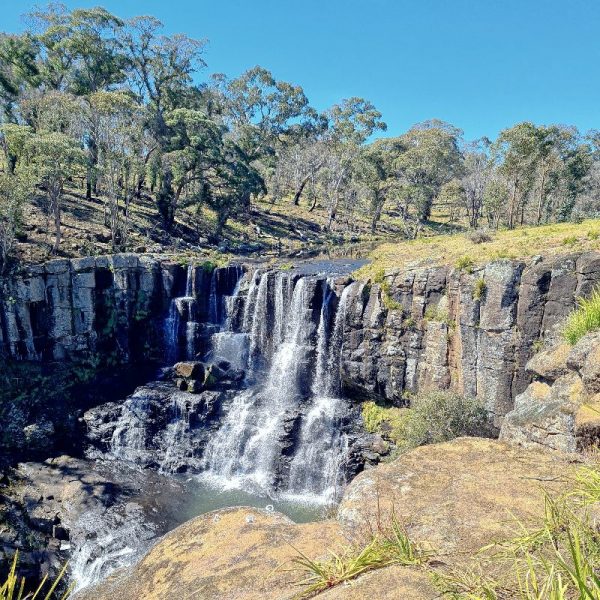
The lower falls viewing platform and walk are closed because of significant damage during the 2020 bushfire season. The top lookout platform, which is an easy walk from the car park, was damaged; however, there is still an unobstructed view of the top falls, as seen above.
The falls are known to the Gumbaynggirr people as ‘Martiam’, which means ‘the great falls”.
The town of Ebor is a short walk from here; you can take a track from the car park to the village shops. Motorhome and caravan camping is available for free at the nearby Ebor Motel.
Where: Ebor is almost halfway between Armidale (80km) and Coffs Harbour (110km) along the Waterfall Way.
Difficulty: Easy walk, only 100m to the main lookout from the parking area. Wheelchair users can access the top lookout with help.
Road access: A sealed road, easy access for all vehicles and a large parking area.
Check out our trip on the NSW Waterfall Way to plan your itinerary.
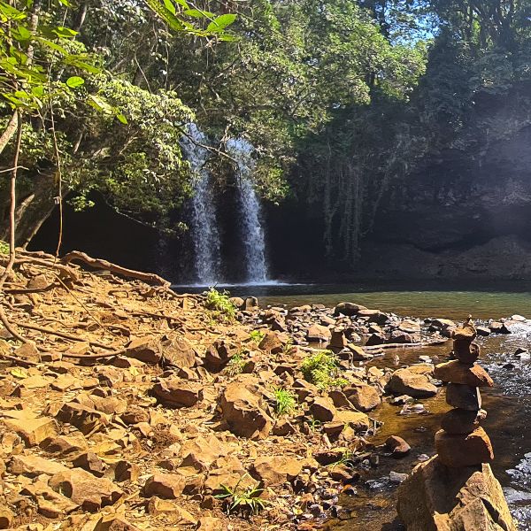
Ellenborough Falls – Elands
Ellenborough Falls, near Taree, is a horsetail fall that plunges 160m (520 ft) as a single drop from Bulga Plateau at Elands. This is one of only a few falls listed here that you can take your dog to, as most are inside National Parks.
We have family living nearby in Forster, and they say this is a very popular day trip for locals on the weekend who head here to swim and picnic.
Ellenborough Falls is the second-highest single-drop waterfall in the Southern Hemisphere.
Walks at Ellenborough Falls
Your first glimpse of the falls is just a few metres from the car park and with minimal effort. However, if you have time, we highly suggest you continue walking.
There is a great track running around the top level of the falls, which allows you to see the falls from various lookouts. You need to head down a few stairs, but nothing too strenuous.
About 500m along the trail, the Knoll Lookout puts you directly opposite the falls and is a great place to get a photo.
Those with decent fitness can take the 640 odd steps to the bottom of Ellenborough Falls. It’s not a long walk, just a long way down. Take your time and stop when you need to, and you will be fine. If I can do it, almost anyone can!
Tip: There is a kiosk here open Friday to Sunday if you fancy a snack or reward after climbing all those stairs 😉
Note: Ellenborough has a campground, but it is quite a drive from the actual falls.
We decided not to take our motorhome along this road because of insurance concerns, so we used a creative commons shot.
Where: Elands is approx 50km from Taree
Difficulty: Very easy for the top lookout, moderate fitness for the stairs to the bottom
Road Access: Sealed and unsealed – most cars can manage the road.
While you are nearby, we suggest spending some time in Forster and checking out its beautiful beaches.
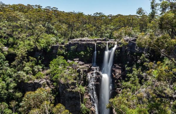
Fitzroy Falls – Morton National Park
One of the most popular sites in the Southern Highlands, there is water flowing over these falls even in very dry times. Apparently, it has only run dry once in known history, so it’s always a pretty good bet; however, it is spectacular if you can visit after some decent rain.
Fitzroy Falls is one spot you will probably have to share with others. In fact, to secure a space in the small car park on weekends, it’s best to arrive before the visitors’ centre opens at 9am.
Nearby Walks
There are two main walks here:
- The West Rim Track – 4km return walk, the first part of which is suitable for everyone
- The East Rim walk – also known as the Wildflower Walk, 6.7km is a little more challenging but still a relatively easy track.
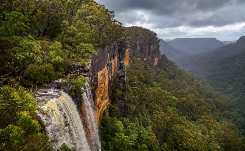
Watching the water rush 60 metres over the edge is a spectacular sight on the West Rim Walk. The first part of the track is suitable for wheelchairs and prams with some assistance. In total, five lookouts line this walk, the first, Jersey Lookout, then Twin Falls, the Grotto, Starkey’s Lookout and Renown Lookout. This is a fabulous family bushwalk.
Tip: Be sure to pop into the Visitors Centre for some great background on the area, where you can learn about both Aboriginal and colonial history.
Where: Fitzroy Falls Visitors Centre
Difficulty: A moderately easy walk – the first section of the west rim has wheelchair access.
Road Access: Easy access with sealed roads but a small area to park. Parking is $4 per car.
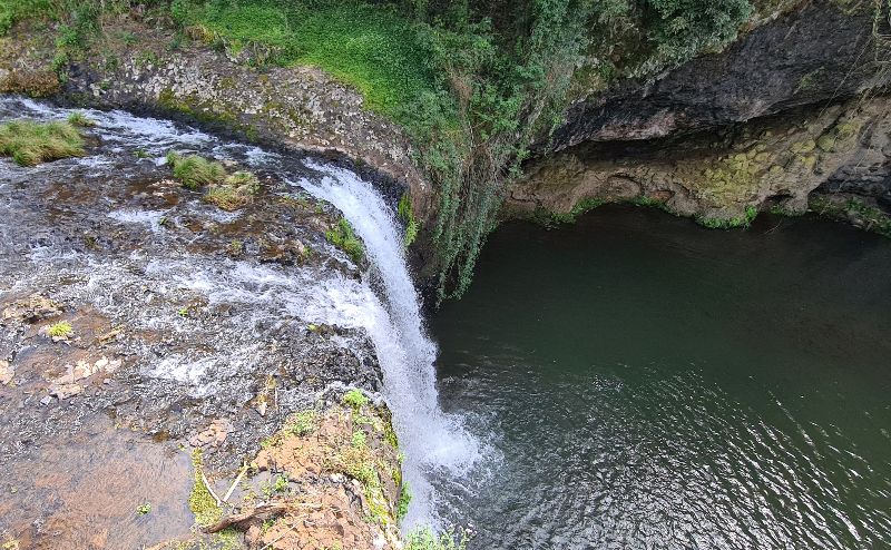
Killen Falls – Tintenbar
Killen Falls is a 10-metre high plunge fall just west of Ballina on the NSW North Coast. If you are yearning to swim under a waterfall, Killen delivers. You can also walk behind the waterfall here. Although access is not as easy as at Crystal Shower Falls in Dorrigo, it is a much shorter walk.
The top viewing platform at Killen is just a few hundred metres from the car park. The walk to the base is another 500m of rough track and about 200m of rocky riverside rock hopping to get to the waterhole and base of the falls.
On our visit in August 2020, the water looked lovely and clean, although not warm enough to tempt me to enter. You really need to have running shoes or something similar to climb across the rocks. Depending on how hard the falls are tumbling down, things can get slippery too.
Apparently, visitors flock to the area in large numbers in summer, so try to arrive early if you want to experience the view in peace. On our mid-winter visit, we passed two other couples.
Tip: There are also not many places to sit when you reach the base – most of the ground is very rocky, so we would not suggest this is a good picnic spot.
Where: Killen Falls Drive, Tintenbar 20 mins from Ballina
Difficulty: Easy path to the top viewing platform. Basic rock hopping is required to reach the base.
Road Access: Sealed road with a small car park. Large vehicles can park just before the entry on the side of the road.
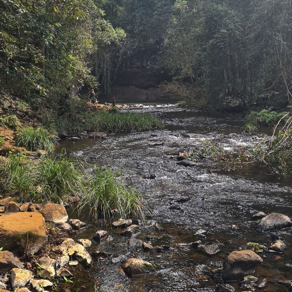
Madden Falls – Dharawal National Park
Perhaps the least known National Park in Sydney, Dharawal’s Madden Falls, is a nice, easy 1km walking track suitable for the entire family. Dharawal is one of Sydney’s newest National Parks, only joining the fold in 2012.
Madden Falls usually offers 3 or 4 thin streams that fall to a second-tier below. Heavy rain will see these join, and the sight can be quite impressive. Regardless, this is a lovely spot easily explored without too much effort.
Tip: If you have a bit of extra energy from the Maddens Fall car park, take the Minerva Pool Walking Track, which winds through the traditional country of the Aboriginal Dharawal People.
Being a sacred women’s place, the Tharawal Local Aboriginal Land Council asks that only women and children enter the waters of Minerva Pool, showing respect to the cultural importance of this site.
Where: Darkes Forest Road, off the Princes Highway 17km from Heathcote
Difficulty: Easy, suitable for families
Road Access: A sealed road – suitable for two-wheel-drive
Check out our favourite picnic spots in Sydney for more days close to the city.
Minnamurra Falls – Budderoo National Park
Located in the lush rainforest, just a short drive from Kiama on the Illawarra Coast, the Falls Walk at Minnamurra is a great workout that is perfect for spring and summer when the rainforest will keep temperatures a little lower.
The falls themselves are two-tiered, but you really only get a good look at the top of the falls. As kids, we had loads of fun at the bottom of these falls, but access to the lower section was cut off years ago because of a landslide, and now, you can only really look down on this part.
The walk starts at the Rainforest Centre and can be combined with the Rainforest Loop walk, giving you a 4.2km track. Another fun, family-friendly walk that is lovely on a summer’s day.
Where: Minnamurra Falls Road, Jamberoo Valley west of Kiama
Difficulty: Steep walk with some steps – average fitness recommended.
Road Access: Easy, sealed with some parking for large vehicles available
Nellies Glen – Budderoo National Park
A small waterfall close to Carrington Falls, Nellies Glen is an easy walk and offers a lovely picnic ground and swimming spot. While walking to the falls is relatively easy, it can be slippery, so resist the urge to walk to the pool in thongs.
The water here is not too deep, but it is perfect for a swim on a warm day. It can get a little crazy in summer on weekends, so arrive early if you can. We visited in late April midweek and have the place all to ourselves.
Tip: If you miss out on parking at Nellie’s Glen picnic ground car park, continue to the Blue Pool car park, it’s a short walk back.
Where: Cloonty Road at the Carrington Falls sign or Jamberoo Mountain Road, take the Carrington Falls turnoff. It’s about 10km from Robertson.
Difficulty: easy
Road Access: Some of the road is unsealed but suitable for a two-wheel drive. A tiny parking area and popular in summer.
Somersby Falls – Brisbane Waters National Park
Located in the east of Brisbane Water National Park, Somersby Falls is a popular picnic spot for Gosford locals, with many Sydneysiders also heading here on summer weekends.
The Somersby Falls walking track is a short walk, less than 500m return, that will take you from the top to the bottom of the falls. The small pool at the bottom is unsuitable for swimming, but it’s lovely to dip your toes in.
There are two drops that make up Somersby Falls, the top drop is only 100m along the track, and some say the prettiest of the two, so if you are not up to the stairs to the base, then go this far and return.
The walk to the bottom is easy, but there are a lot of stairs, which are a little uneven and often wet – as long as you have good shoes, you should be fine.
Tip: This is a great place to practice your waterfall photography skills, especially if you can visit midweek when you are more likely to have the place to yourself.
Where: 70km north of Sydney or 9km west of Gosford – near the Australian Reptile Park
Difficulty: A little steep and often slippery, but not a strenuous walk.
Road Access: Easy – parking is $8 per car. Park before the official entry, and you can walk in.
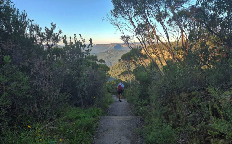
Wentworth Falls – Blue Mountains National Park
The most popular of the Blue Mountains waterfalls, Wentworth Falls, has delighted visitors since the early 1900s. Featuring a triple-tiered drop after the Three Sisters, one of the most visited Blue Mountains National Park sites.
There are a couple of lookouts here to visit, and viewing the top requires little effort. The best view is from Fletchers Lookout involves a 1.4km walk with about 200 steps. Other tracks will take you to the base of the falls. The official site gives more details.
Where: 100km west of Sydney
Difficulty: 1.4km and 200 steps to a good lookout
Road Access: easy access along a sealed road with plenty of parking.
There are lots of beautiful picnic spots in the Blue Mountains you might want to consider
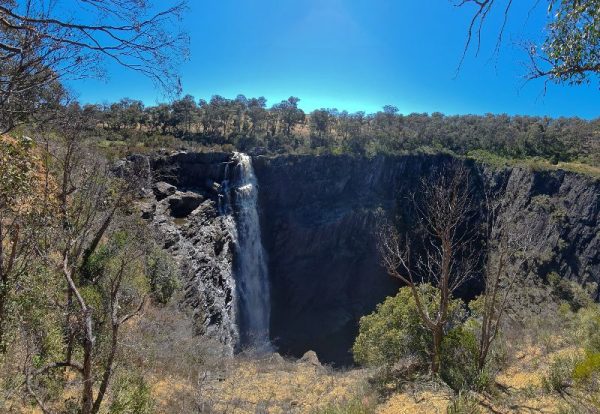
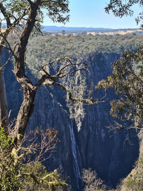
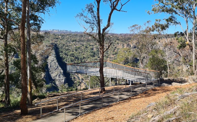
Wollomombi Falls – Oxley Wild Rivers National Park
Wollomombi Falls, just east of Armidale, is the second-highest in Australia, with a 220m (720 ft) combined drop. This plunge falls on the Wollomombi River in the Northern Tablelands is an easy stopover on the Waterfall Way drive, and it required little effort to view the falls themselves.
Wollomombi is said to be an Aboriginal word meaning “meeting of the waters”.
Just off the main road along a gravel track, you will find a large picnic area with a new undercover BBQ area that was spotlessly clean on our recent visit.
Along with the two lookouts located a short walk from the car park and picnic area are two main walking tracks
- Wollomombi Walking Track – 4km relatively easy (grade 3) walk along the Wollomombi Gorge with a chance to spot some kangaroos and, if you are fortunate, perhaps a platypus.
- Chandler Walking Track – While still listed in guidebooks and many websites, Chandler Walking Track is partly closed because of ongoing erosion) however, you get as far as Checks Lookout, only 1.4km along for expansive views of the slate gorge, and when rain has been heavy, Chandler falls, which is often dry, is also visible.
Where: 40km east of Armidale along the Waterfall Way at Hillgrove
Difficulty: Easy just a couple of hundred metres to the main viewing platform from the car park.
Road Access: Easy access via a short gravel road from main turn off – plenty of parking for large vehicles.
Frequently Asked Questions about Waterfalls in NSW
What types of waterfalls can I find in NSW?
Did you know there are ten different types of waterfalls? Most waterfalls we have found in NSW are one of the following types:
- Plunge falls – Dangar, Carrington, Fitzroy, Wollomombi
- Tiered or multi-step falls – Belmore, Ebor, Wentworth
- Cascading falls – Apsley
- Horsetail falls – Ellenborough
There are also Punchbowl Waterfalls, Frozen Waterfalls, Fan Waterfalls, Chutes, Cataracts, Cascades, and Block Waterfalls, but we have not found these here yet.
Which NSW waterfalls are best to swim in?
Killen Falls, Nellies Glen, Winifred Falls, Wattamolla Falls and Ellenborough Falls are some of the most popular waterfalls to swim in.
Which waterfalls in New South Wales can I take my dog to?
Many of these waterfalls are inside the National Park boundary, meaning you need to leave your four-legged friend at home; however, there are three waterfalls in Sydney where you can take your dog.
- Dangar Falls
- Ellenborough Falls
- Killen Falls
There are also some small falls around Lawson in the Blue Mountains that are dog friendly.
Which waterfalls are accessible to wheelchair users?
Fitzroy Falls has a wheelchair-accessible lookout. Wollomombi Falls’ new viewing platform is accessible. Have Wheelchair Will Travel has written about their experience using the Trailrider chair at Dorrigo National Park here.
When is the best time of year to visit waterfalls?
Anytime it rains, summer can be problematic with high visitor numbers and bushfire risk. Always check the official website of the park or conservation area before you head off.
Where are the highest waterfalls in NSW?
We have found a couple of answers. They list Wollomombi Falls in Oxley Wild Rivers NP at 260m, but if you add the horseshoe drop to the cascade, it is 424 metres, making it the highest. Ellenborough Falls at 200m is the tallest single-drop waterfall in NSW; it’s also the second tallest in the southern hemisphere.
Which waterfalls are closest to Sydney?
In the South of Sydney, you have two falls in Dharawal National Park and seven in the Royal National Park, all less than an hour from the city.
Heading North you have Upper Gledhill Falls in Kur-ring-gai National Park, which is still on our list of waterfalls we need to visit, and Somersby Falls in Brisbane Water National Park.
Heading west, Wentworth Falls in the Blue Mountains is about 90 minutes from Sydney. There are some smaller falls in the Lower Blue Mountains.
Which waterfalls can you walk behind?
You can access an official track to the back of Crystal Shower Falls in Dorrigo National Park. You can also scramble over rocks or walk along the riverbed to get in behind Killen Falls near Ballina.
Safety Tip
Please don’t jump off waterfalls – unless on an organised and licensed activity. Several of the falls above have been the site of fatalities.
Check out these 24 Getaway ideas and escape Sydney this weekend
Got a question? Head over to our Sydney Expert Facebook Group and ask a local.
wow had no idea there were so many in NSW..thank you for sharing.